Saturday, 1 August 2009

the 33 islands in negara brunei darussalam
GPS & HDS holders... lets fish! safety come first!
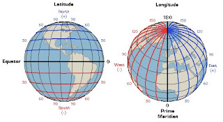
Island - latitude - longitude - district
1. anjung batu - 4.867 - 114.917 - bm
2. api api - tu
3. bakuku - 4.78333 - 114.61667 - tu
4. baru baru - 4.9 - 115.03333 - bm
5. bedukang - 4.98333 - 115.05 - bm
6. berambang - 4.86667 - 114.89333 - bm
7. berbunut - 4.88333 - 115.03333 - bm
8. chermin - 4.93333 - 115.01667 - bm
9. kaingaran - 4.95 - 115.03333 - bm
10. kibi - 4.76667 - 115.03333 - tm
11. kitang - 4.88333 - 115.1 - tm
12. luba - 4.85 - 114.88333 - bm
13. lumut lunting - 4.86667 - 114.95 - bm
14. muara besar - 5 - 115.1 - bm
15. musa - bm
16. pasir tengah - bm
17. pelong pelongan - 5.083 - 115.033 - bm
18. pelumpong - 5.050 - 115.110 - bm
19. pepatan - 4.9166 - 115.03333 - bm
20. pituat - tm
21. pungit - 4.9833 - 114.83333 - bm
22. ranggu - 4.85 - 114.9 - bm
23. salar - 4.98333 - 115.0333 - bm
24. salawat - 4.76667 - 114.6 - tu
25. selajak - tm
26. selirong - 4.833 - 115.110 - tm
27. siarau - 4.8- 115.03333 - tm
28. sibungor - 4.86667 - 114.95 - bm
29. silamak - 4.88333 - 115.05 - bm
30. silipan - 4.883 - 115.050 - bm
31. simangga besar - bm
32. tanjung maya - 4.76667 -114.66667 - tu
33. tarap - 4.32 - 114.32 - tm
bm - brunei / muara district
tu - tutong district
tm - temburong district
pulau anjung batu (nakhoda ragam)
pulau chermin
pulau kaingaran
pulau lumut lunting
His Royal Highness The Crown Prince Haji Al Muhtadee Billah of Brunei Darussalam at pulau selirong
selirong island is brunei's largest island covering 2566 hectares in total land size. To be known as the best tropical mangrove forest in south east asia i.e. the mangrove amongst the oldest in the world with tree trunks reputedly bigger than neighbouring countries
- home of amazing flora & fauna species
- 95% mangrove forests are tidal swamps
- bakau minyak (rhizophora apiculata)
- bakau kurap (rhizophora mucronata)
- linggadai (bruguiera gymnorrhiza)
- lobsters mounds usually covered by piai fern (acrostichum aureum) abound in areas occupied by the xylocarpus granatum (nyireh mangrove)
- numerous semi-permanent lakes
- one of the last mangrove areas with all major habitats & forest types nature on earth
- bebarahan, belais, ketam, kerapu, ketambak, kitang, kurau, languran, pari, selungsong, sembilang, tabana, umpak & ungah!
credits: hasmom - survey dept, ministry of development nbd / pelita brunei / brudirect.com / satelliteviews.net / tageo.com / geonames.org / mapplanet.com / mapsof.net / various sources


